MERLIN
VESSEL – BASED LASER SCANNER


Merlin is the marine LiDAR (Light Detection and Ranging) system developed specifically for costeffective and safer coastal, offshore and inland waterway surveying. Extremely robust, portable, and well-engineered, Merlin provides eye-safe, long-range laser scanning that enables the capture, processing, and analysis of geospatial point cloud data quickly and accurately.
Safer, faster, more efficient surveying with Merlin
Seamless integration with existing echosounder technology enables the fast and effective acquisition of time-tagged survey data above and below the water simultaneously.

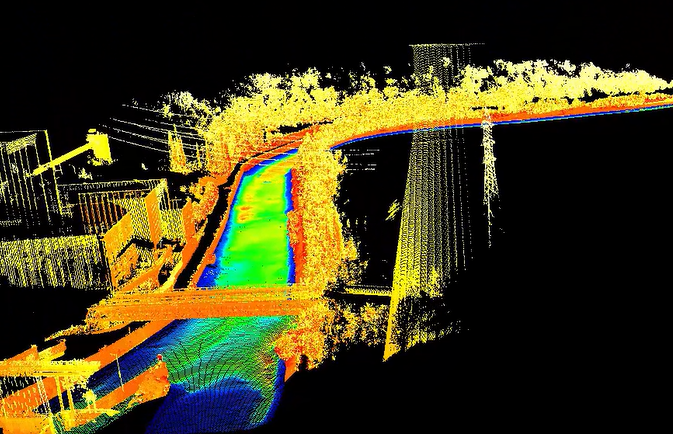
Map the full environment in a single survey
Information acquired by Carlson’s time-tagged Merlin marine laser scanner combines seamlessly with bathymetric echosounder data for complete datasets
that reveal the full landscape above and below the waterline in the same survey. Obtaining a full 360° point cloud with Merlin quickly and safely:
- Speeds up project timescales
- Minimizes the amount of time crew spend in potentially hazardous areas, and
- Reduces the surveying costs associated withcomplex vessel-based surveying assignments
Key Features
- IP66 (EN 60945) water and dust resistance
- 250 m laser range (maximum)
- ±1 cm laser accuracy
- 360° field of view
Key Benefits
- Saves on setup: Seamless integration with existing hardware and software means no need to duplicate equipment, infrastructure, or technologies already owned
- Minimizes training costs: The low maintenance plug-and-play Merlin system is easy to install and operate, eliminating the need for specialist training. It is also compatible with industrystandard software packages
- Improves worker safety: Fast installation, deployment, and speed of data capture reduce the amount of time spent in potentially hazardous marine environment.
Safe, flexible, and easy to operate for a wide range of applications
Merlin is ready to install out of the box with no customization required. The mounting plate can either be permanently welded into place or attached temporarily to a mast or cabin roof by three simple screws.
Merlin’s 250 m range* addresses the challenges of safely and accurately mapping the full landscape above the waterline – including the shoreline, coastal features, manmade structures, and more – as it enables accurate data acquisition from a safe distance. These challenges include avoiding hazardous natural features and dealing with unpredictable weather conditions.
Merlin also comes with its own diagnostic tool, which can be used to set up the system with existing infrastructure, such as port numbers and IP addresses. It also enables operators to select
and test a timing source and troubleshoot.
Many uses for Merlin’s high-quality 3D data
- Monitoring coastal change by comparing old and new information
- Creating navigation charts without venturing into hazardous coastal zones
- Updating risk management and flood models to predict future events by using historic data
- Assisting with urban planning with identification of key marine features
- Collecting detailed information safely and quickly from high traffic waterways
Connect an additional sensor
The option to connect a second Merlin unit via a specialized top-side interface box further helps to reduce project timelines and improve point cloud density. Benefits of deploying two Merlin units on one vessel include:
- Reducing the amount of shadowing encountered during scanning
- Enabling the capture of more points per second for more detailed datasets in a shorter amount of time
- Increasing the quality and quantity of scan data that can be captured, for improved decision making
Merlin: Compatible with all major software
The Merlin vessel-based lidar system quickly measures and records time-tagged geo-referenced
data points, which can then be calibrated and processed into a finished point cloud by the following packages:
- HYSWEEP® multibeam collection and editing software from HYPACK®
- NaviScan and Kuda sonar and laser data acquisition software from EIVA
- QINSy hydrographic data acquisition software from QPS
- Teledyne PDS software for hydrographic survey and dredging operations
The processed point cloud can then be exported in formats such as LAS or XYZ into a CAD package such as Carlson Point Cloud, to Carlson P3D Topo to produce a 3D model, create surfaces, or to export to other file formats including DXF or DWG. Merlin’s universal interface ensures operator familiarity and ease of use.
